Remember our challenge for this week? It was based on Ramón's photo.
To solve this problem I had a bit of a headstart. I knew the photo was from Ramón, and he told me it was of Popocatépetl. But if you didn't know that to start, I would do a modified version of what Owen posted. My first query would have been:
[ volcano Chiconauhquiauhitl ]
My reasoning would be that if there's a temple dedicated to Chiconauhquiauhitl, and that an outflow from the volcano reached it, then there would probably be a web-page with this pair of terms on it. (Keep in mind, that's what you're doing when web-searching; looking for pages with answers that are highly correlated with the key terms of your core question.) And that page would probably tell me the name of the volcano.
Sure enough, that search quickly shows us that the nearby volcano is Popocatépetl (or "Popo" for short). (BTW, here's a link to a page that tells you how to pronounce the proper name of the volcano. Ramón y Juan, does this sound right to you?)
I also knew that it had erupted recently (from my reading of the news). Here's a speeded-up version of the eruption from June, 2013:
So we now have answers to two of the questions: What's the volcano's name? (Popocatépetl) And will it erupt again? Yes, it's active now! (See below for more data on this.)
Now... what about a nearby pyramid? Let's repeat a variation on that first query:
[ pyramid Chiconauhquiauhitl ]
And we discover that it's the Great Pyramid of Cholula. It's the largest archaeological site of a pyramid in the New World, measuring 55 metres (180 ft) above the surrounding plain. In its final form the base was around 400 by 400 metres (1,300 by 1,300 ft).
Interestingly, the pyramid was traditionally viewed as having been dedicated to the god Quetzalcoatl, but more recent discoveries indicate it was actually dedicated to Chiconauhquiauhitl, the godess of the Nine Rains. It was constructed in multiple states, beginning in the 3rd century BCE and work on (and off) throughout until the 9th century CE.
Now that I know where the volcano is, and where the temple is, I can create a map (with a couple of overlay lines showing the shortest path from volcano to temple).
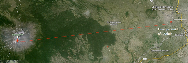
That distance is around 45 km (27.9 miles). As we know from the eruption of Mount St. Helens in 1980, mudflows can easy travel over 50 miles from the volcano center.
So, how can we find out when the last time lava or mud (also called a lahar) flow reached at least 45 km to the east?
Like Rosemary, I first checked out the references at the Wikipedia article, and found what I considered a reputable source via reference #1 (which points to a Smithsonian Museum article).
The Smithsonian Institute Global Volcanism Program has an great website for volcanoes worldwide. Popo's last major eruption happened in 823 A.D. (you can check out the map at http://www.volcano.si.edu/ )
From there, I found a link to Oregon State website showing that last great eruption was 822 A.D. As they say, “Lahars [destructive mudflow] buried the lower 1 meter of the Great Pyramid of Cholula and the Puebla Valley.”
Sounds pretty bad.
Ramón pursued a purely Spanish search strategy (which makes a lot of sense, given that it's in Mexico.) His queries:
[Distancia erupciones Popocatepetl]
[Popo eruption distance]
These queries led to these results (in English):
Potential for Large Eruptions at Popocatepetl -- which also answers the 3rd question (yes, it will erupt again in the near future).
How much pressure did it take to pop the top off Mexico’s Popocatépetl volcano? Shows videos, maps and data based on volcanic plume of June 17, 2013
In Spanish: Áreas de peligro por flujo de material volcánico Areas that could be affected by eruption. Pyramid is in the Moderate risk zone.
In Spanish [desastres naturales piramide cholula] "Natural disasters Cholula Pyramid]
El Popocatepetl y la Legendaria Lluvia de Fuego Mentions "Leyenda de los Soles"
Ramón continues his search with:
Juan pointed out that "One of the websites that confirmed the 700-850 AD guesstimate was CENAPRED/UNAM Popocatépetl History. 800 AD is obviously not an exact date, but an approximation... the Foundation for the Advancement of Mesoamerican Studies doing a radiocarbon dating shows 700-850 AD results."
For credible resources, Rosemary suggests (and I'm quoting her here):
And I agree. Typically, Scholar will have very good resources, but it might take some time to collect, organize, read (and look up all the words you don't know).
We'll return to this topic in the future, as it's a critical skill for advanced search research.
Search Lessons: As Ramón pointed out, searching in the local language can often reveal sources that aren't otherwise available. That's an incredibly handy thing to know when you're searching for international content.
Second, bridging searches (as I did when I searched for [volcano Chiconauhquiauhitl ] and then searched for the nearby pyramid to get from volcano to pyramid name) is another good strategy. Often complex searches come in pieces. "Bridging" to find one piece in common (the name of the volcano) then "unlocks" all of the other search steps and lets you figure it all out together.
Finally, as I've said before, "credible" resources are largely based on sites you know and trust. Having multiple sources for a piece of information (e.g., the date the pyramid had the lahar mud flow up and onto the doorstep) is a good thing to do. Pay attention to the publishing institution (e.g., Oregon State) and verify that they actually DO volcano studies by looking for the institution's web site.
Knowing the name of the institution is a good thing, but be sure they actually know what they're talking about!
With that...
Search on! Credibly!
 |
| Foto de Ramón. |
1. In what year did an outflow from this volcano cover some part of a nearby pyramid that was considered sacred to the rain goddess Chiconauhquiauhitl? (And.. What's the name of the pyramid?)
2. What are the volcanic domes in this caldera made of?
3. Will this volcano erupt again?
To solve this problem I had a bit of a headstart. I knew the photo was from Ramón, and he told me it was of Popocatépetl. But if you didn't know that to start, I would do a modified version of what Owen posted. My first query would have been:
[ volcano Chiconauhquiauhitl ]
My reasoning would be that if there's a temple dedicated to Chiconauhquiauhitl, and that an outflow from the volcano reached it, then there would probably be a web-page with this pair of terms on it. (Keep in mind, that's what you're doing when web-searching; looking for pages with answers that are highly correlated with the key terms of your core question.) And that page would probably tell me the name of the volcano.
Sure enough, that search quickly shows us that the nearby volcano is Popocatépetl (or "Popo" for short). (BTW, here's a link to a page that tells you how to pronounce the proper name of the volcano. Ramón y Juan, does this sound right to you?)
I also knew that it had erupted recently (from my reading of the news). Here's a speeded-up version of the eruption from June, 2013:
So we now have answers to two of the questions: What's the volcano's name? (Popocatépetl) And will it erupt again? Yes, it's active now! (See below for more data on this.)
Now... what about a nearby pyramid? Let's repeat a variation on that first query:
[ pyramid Chiconauhquiauhitl ]
Interestingly, the pyramid was traditionally viewed as having been dedicated to the god Quetzalcoatl, but more recent discoveries indicate it was actually dedicated to Chiconauhquiauhitl, the godess of the Nine Rains. It was constructed in multiple states, beginning in the 3rd century BCE and work on (and off) throughout until the 9th century CE.
Now that I know where the volcano is, and where the temple is, I can create a map (with a couple of overlay lines showing the shortest path from volcano to temple).

That distance is around 45 km (27.9 miles). As we know from the eruption of Mount St. Helens in 1980, mudflows can easy travel over 50 miles from the volcano center.
So, how can we find out when the last time lava or mud (also called a lahar) flow reached at least 45 km to the east?
Like Rosemary, I first checked out the references at the Wikipedia article, and found what I considered a reputable source via reference #1 (which points to a Smithsonian Museum article).
The Smithsonian Institute Global Volcanism Program has an great website for volcanoes worldwide. Popo's last major eruption happened in 823 A.D. (you can check out the map at http://www.volcano.si.edu/ )
From there, I found a link to Oregon State website showing that last great eruption was 822 A.D. As they say, “Lahars [destructive mudflow] buried the lower 1 meter of the Great Pyramid of Cholula and the Puebla Valley.”
Sounds pretty bad.
Ramón pursued a purely Spanish search strategy (which makes a lot of sense, given that it's in Mexico.) His queries:
[Distancia erupciones Popocatepetl]
[Popo eruption distance]
These queries led to these results (in English):
Potential for Large Eruptions at Popocatepetl -- which also answers the 3rd question (yes, it will erupt again in the near future).
How much pressure did it take to pop the top off Mexico’s Popocatépetl volcano? Shows videos, maps and data based on volcanic plume of June 17, 2013
In Spanish: Áreas de peligro por flujo de material volcánico Areas that could be affected by eruption. Pyramid is in the Moderate risk zone.
In Spanish [desastres naturales piramide cholula] "Natural disasters Cholula Pyramid]
El Popocatepetl y la Legendaria Lluvia de Fuego Mentions "Leyenda de los Soles"
Ramón continues his search with:
[Cholula pyramid eruption history]
Book : Dangerous Neighbors: Volcanoes and Cities - Page 52 Base of Pyramid was buried by volcanic mudflows.
Book : Dangerous Neighbors: Volcanoes and Cities - Page 52 Base of Pyramid was buried by volcanic mudflows.
It's worth knowing that Cenapred is the agency that monitors Volcanoes in Mexico ("Center for Prevention of Disasters") They have a timeline of previous Popo eruptions, Historia eruptiva del volcán Popocatépetl , which includes the eruption in the middle 800's.
Photos of the Popo from Cenapred Cameras -- apparently these cameras take pictures whenever anything happens on Popo.
Photos of the Popo from Cenapred Cameras -- apparently these cameras take pictures whenever anything happens on Popo.
For credible resources, Rosemary suggests (and I'm quoting her here):
CEOS (Committee on Earth Observation Satellites) looks like a huge conglomeration of agencies coming together to utilize satellites for environmental observations. It has a section specific to volcanoes and lists projects involved with CEOS for monitoring geo-hazards.
Along with these projects we can gather the names of various people, institutes and agencies involved such as USGS, NOAA, NASA, along with several agencies worldwide. For the purposes of credibility it helps to identify key names related to our subject that in turn can lead us to other sites and support our findings.
When I think of credibility I immediately think of Google Scholar. However when dealing with such a technical and complex subject such as volcano composition, structure and eruptions, I find it easy to get swallowed up when viewing intellectual papers. For me knowing how to glean useful information for our searches from in-depth papers would be quite beneficial.
And I agree. Typically, Scholar will have very good resources, but it might take some time to collect, organize, read (and look up all the words you don't know).
We'll return to this topic in the future, as it's a critical skill for advanced search research.
Search Lessons: As Ramón pointed out, searching in the local language can often reveal sources that aren't otherwise available. That's an incredibly handy thing to know when you're searching for international content.
Second, bridging searches (as I did when I searched for [volcano Chiconauhquiauhitl ] and then searched for the nearby pyramid to get from volcano to pyramid name) is another good strategy. Often complex searches come in pieces. "Bridging" to find one piece in common (the name of the volcano) then "unlocks" all of the other search steps and lets you figure it all out together.
Finally, as I've said before, "credible" resources are largely based on sites you know and trust. Having multiple sources for a piece of information (e.g., the date the pyramid had the lahar mud flow up and onto the doorstep) is a good thing to do. Pay attention to the publishing institution (e.g., Oregon State) and verify that they actually DO volcano studies by looking for the institution's web site.
Knowing the name of the institution is a good thing, but be sure they actually know what they're talking about!
With that...
Search on! Credibly!
Hello Dr. Russell and fellow SRS
ReplyDeleteThis was for me a very intersting SearchResearch Challenge. I learned a lot, again. I like the credible sources topic and the link that RoseMary found.
The sound of Popocatépetl pronunciation is excellent.
About the Cenapred's photos. These are updated each minute 24/7. In the link Dr. Russell posted they just select some. I don´t know how they do that. I'll write and ask them.
The four cameras that monitors Popocatépetl.
Altzomoni
Tlamacas
Tianguismanalco
Tochimilco
Have a nice weekend.
Did you skip one?
ReplyDelete2. What are the volcanic domes in this caldera made of?
Very interesting challenge indeed! I'm afraid I've been very short of time lately to try to solve the challenges but I've been reading questions and answers anyway.
ReplyDeleteI didn't know Audioboo.fm. It looks like a less developed version of what the site I use (a lot, in fact) to check pronunciations: forvo.com. Here's six locals saying Popocatépetl (5 in Spanish, 1 in Nahuatl): http://www.forvo.com/search/Popocatepetl (they all sound pretty much the same).
Have a nice weekend, everybody.
Ooops. Yes I did miss it. See next post.
ReplyDeleteOver the weekend I contact Ramón on Google+ to see if he could help track down the sources cited in the article they published where studies show the lahars did not reach pyramid as suggested in other places. The citations say the papers are unpublished but I thought in the time since that article was first published that they may have found their way online. Ramón went to work and started sharing new finds with me. In one of those links were email addresses for Drs. Plunket and Uruñuela. One of the lessons that has been taught here is to reach out to experts So I did.
ReplyDeleteFred, great find and great SearchResearch. I'm sure Dr. Russell must feel very proud of you. He is a fantastic teacher and his Challenges allow us to work, know and learn more with each post.
DeleteYou did a fantastic job, Fred. Thanks for mentioning my name, and the truth is that you did 99.9% (keep researching, found articles, shared them, wrote to Dr. Plunket and again share; now with us) of the job. Thanks also to Professor Patricia Plunket for her answer. Now, we know more about Volcano!
Fred, you and Ramón are tenacious lads. Ms. Plunket is most gracious.
DeleteHad been reading her work - found this useful - Patricia Plunket
Two images I liked: Max Ernst "vulcano"and Popo
from here…educational
Perhaps The Great Pyramid of Cholula with Church of Our Lady of Remedies
could be the site of the next meetup? Our Lady would seem a fitting place - see toward bottom of this site: Iglesia de Nuestra Señora de los Remedios, pretty on the inside too or maybe even the slopes of that movie star Popo, ⌘F Popocatépetl think Denzel did a fine job in MoF… jmho. UtV - 34AP seems long ago
either would be better than waiting in the unfinished Ben's Chili Bowl location at DCA - still don't know how I missed the SS locale…
Very nice picture Ramón - made me wonder what elevation you reside at relative to Popo's 17,802 ft - leading 3 sRs posts has to be a record of some kind.
Seems the snow presence could contribute to the potential of lahars - see this example from NZ - Mt Ruapehu
Am surprised there was no mention of my favorite Volcanologist, Dr. James LeBuffett… but then again, I did sit at DCA wondering where everybody was… volcanoes are tough to predict, who knows, maybe while we are watching Popocatépetl, Yellowstone will surprise… or that hill outside Seattle will let go — I don't know. Remember Martinique, Etna, Kilauea, Pinatubo, Eyjafjallajökull, Krakatoa, the unnamed and the undersea… the surface can be an unstable interface.
Dr. Plunket responded to my email and graciously granted me permission to share her answer here.
ReplyDeleteThe proposition that the Cholula Pyramid, and by inference the city of Cholula itself, were buried by a lahar in the ninth century was published in an article by Claus Siebe and his colleagues in Geology in 1996. He interpreted the erosional material around the Great Pyramid as evidence of lahars, however, the archaeological reports of the 1967-1970 excavation season, indicate that the "lahars" are actually the "melt" of the adobe blocks which form the core of the Pyramid itself. The excavations we refer to in the article you cite took place on the university campus to the east of the Pyramid and also just north of San Pedro Cholula's main square, which is about 500 meters to the west of the Pyramid. In neither case was there evidence of lahars, although we did find pumiceous ash covering the Classic period (AD100-650) deposits. The references we cite are archaeological reports for the government agency, the Instituto Nacional de Antropología e Historia. At present we are finishing a book on Cholula that provides a summary of much of this data.
Much of our knowledge of the past activity of Popocatépetl comes from Maria Panfil's MS thesis at Penn State. She worked with us in 1994-95 in order to provide baseline data on the eruptive sequence. Siebe's early ninth century date has yet to be confirmed and it well may be correct. The 1967-1970 excavations at the Pyramid found evidence of an eruption after the ceremonial center of the city ceased to function as such and much of the city was abandoned. This evidence consists of airfall deposits of pumiceous ash (reworked by water), not material from a lahar, that overlies erosional materials from the abandoned Pyramid.
The name Chiconquiahuitl, or 9 Rain, refers to a deity mentioned by the Corregidor of Cholula, Gabriel de Rojas, in response to a questionnaire from the Spanish Crown in 1581 saying that the indigenous population venerated this deity in a small shrine atop the great mound. This was NOT the main temple of the city at that time. When the Spanish arrived in 1519, the main temple, which was indeed dedicated to Quetzalcoatl, was not the Great Pyramid (this had been abandoned, probably in the seventh century, then reoccupied for perhaps between 800 and 1100, only to be abandoned again), but rather a large temple precinct, described by one of Cortes' soldiers, Bernal Díaz del Castillo, which was located on the east side of the main square of San Pedro Cholula where the Franciscan monastery of San Gabriel stands today. When Cholula's sixteenth century temple was burned by the Spaniards during the massacre of October 1519, the indigenous population probably began to make offerings again at the Great Pyramid, which contained so much of their early history.
Popocatépetl is indeed a dangerous volcano. It has erupted many times in the past and, as those of us who live close by well know, it will continue to erupt in the future. We know of the VEI-6 eruption around AD50 (this is very well dated) and also the ninth century eruption, but there were other important events that have left evidence on other parts of the mountain and these still need to be explored.
Regards, Patricia Plunket